Create an account and enjoy the benefits on several portals. Your login details work on this website as well as on myzillertal.at and in the myZillertal app (for iOS and Android).
Reminder sent. Please check your inbox, then login again.
Reminder not sent. Please try again later, or contact support.
Error accessing server.
Personal information
Login credentials
Password must contain a minimum of 8 characters.
Password has to contain at least one upper and one lower case letter.
Password has to contain at least one number and one special character.
It is not permitted to use three consecutive ascending or descending number sequences (e.g., 123, 567, 321, 987) or three identical numbers (e.g., 333, 777) in succession.
Newsletter & legal information
Please accept the terms of service and privacy policy
Or continue with one of these options
Your interests
Pick a variety of interests below to get more personalized recommendations by clicking the images. Note that these can be changed at any time later. You may also skip this setup for now.
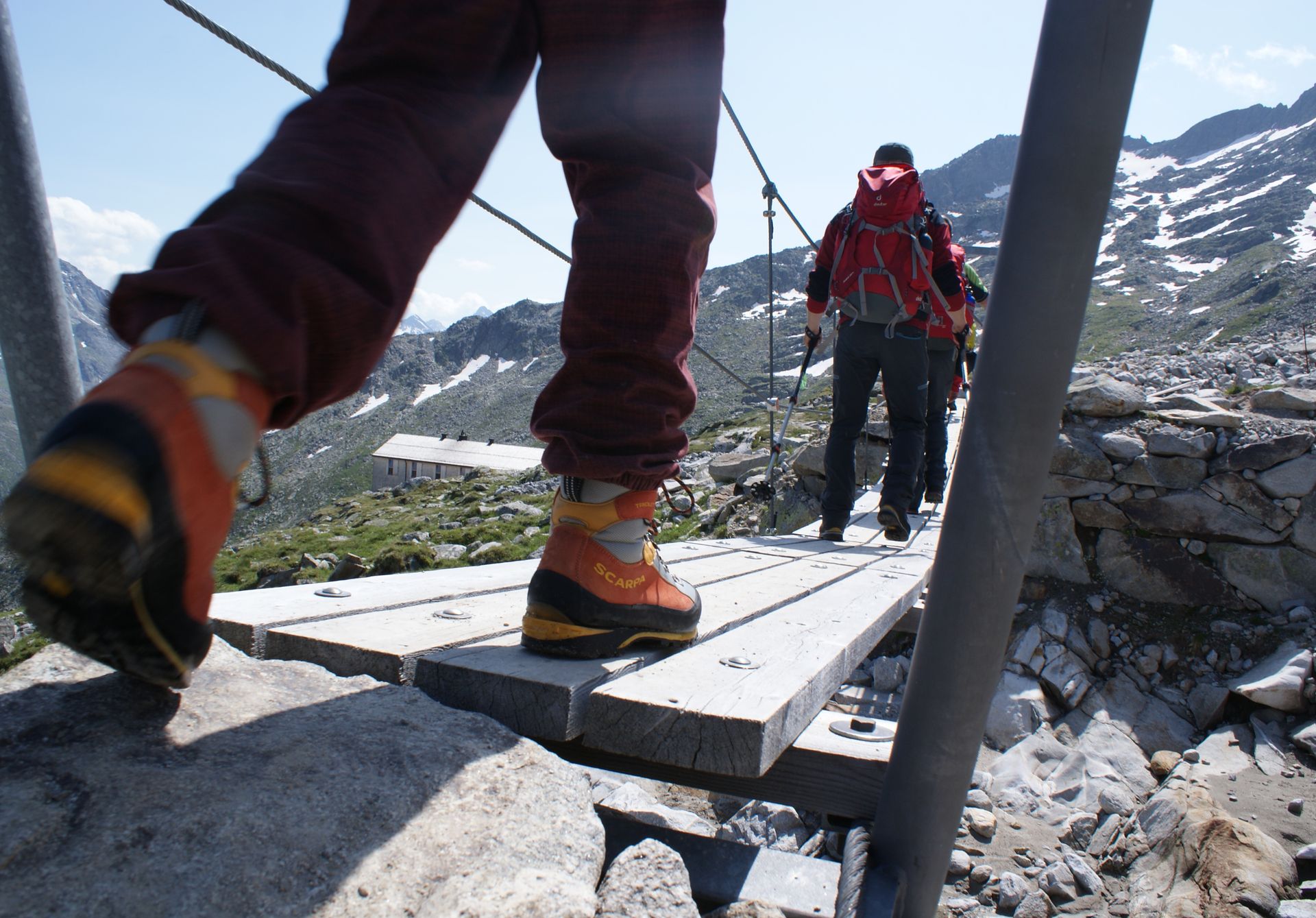
For Peter Habeler, the high trail from Friesenberghaus to the Geraer Hut is one of the most beautiful crossings in the eastern Alps . It is with very good reason that a large part of this area has been under protection since 1991, going uner the title of the Zillertal Alps Nature Park.
Experience the magnificent alpine scenery on the Main Alpine Ridge, encounter marmots and alpine ibex - which in itself is an impressive highlight. Not forgetting, of course, the inviting mountain huts.
Walk in the footsteps of Peter Habeler and allow yourself to be inspired by the magic of the impressive Zillertal Alps.
Whether clockwise or anticlockwise, the aim is to circumnavigate the peaks of the Western Ziller Valley Alps.
This 60 kilometre long, hut to hut round walk leads via six mountain huts with individual distances ranging from 3.5 to 13 kilometres with or without summit ascents. The individual routes are divided into walking times of between 2.5 and 8 hours, with varying levels of difficulty over diverse terrain including easy sections, alpine meadows and gravel trails as well as over rock, moraines and scree.
Route length: 56.1 km
Ascent: 4,230 m / Minimal altitude: 1,345 m
Descent: 4,230 m / Maximum altitude: 2,910 m
Route Description
You start in a northerly direction on path no. 527 to the Steinernen Lamm. A newly prepared section of path leads over old glacier moraines through the start of the Höllwand and further to the Kleegrubenscharte. Pass the Kasererscharte and the Frauenwand before beginning the descent over the Almböden to the Tuxerjochhaus. (Walking time 4.5 - 5 hours)
▲ Peter-Habeler-Route map view
You will make a short descent via path no. 326 a little below the Lärmstange before the path continues in a southeasterly direction to the Spannagelhaus 2,531m. Cross moraines and scree fields to reach the highest point of the trail - the Friesenbergscharte at 2,911m. Descend the serpentine path to the Friesenberghaus. (Walking time 4.5 - 5 hours).
▲ Peter-Habeler-Route map view
From the Friesenberghaus descend briefly past the small Friesenberg lake and then follow the serpentine path steeply upwards. Follow a short section of the Berliner High Alpine Path (Nr.526) as you gently descend to the Olpererhütte. (Walking time 2.5 hours)
▲ Peter-Habeler-Route map view
Follow path no. 502 along a section of the Neumarkter trail to the Unterschrammachkar at 2,280m. Following a short ascent beneath the Ameiskopf (2,400m) walk the steep trail (no. 528) past glacier-smoothed terrain and the Kastenschneid and below the Stamplkees to arrive at the Pfitscherjochhaus. (Walking time 3.5 hours)
▲ Peter-Habeler-Route map view
From the Pfitscherjochhaus pass a small lake and walk along the Landshuter Höhenweg (path no.3 / no.528) through a scraggy stony landscape in a westerly direction. This path was created at the beginning of the 20th century and leads to the Friedrichshöhe and the Landshuter Europa-Hütte. (Walking time 3 hours)
▲ Peter-Habeler-Route map view
Follow the Geistbeck path (no.529) to the Sumpfschartl 2,666 m and continue over the long face in a northerly direction to the inneren Zeischalm and the Nockeralm car park at the end of the Valser valley. The ascent begins at the Gasthaus Touristenrast and follows path no. 502 through the alms of the far Valser Valley for 2.5km to the base station of the goods cable car. The flat path then snakes its way through a beautiful pine forest to the Ochsenhütte. From there the route continues east over high alpine meadows to the Geraerhütte at 2,324m. (Walking time 7 hours)
From Ginzling - Friesenberghaus
From the Naturparkhaus at approx. 1,000m above sea level walk in the direction of the parish church and then follow the Adlerweg (Eagle’s path) in the direction of Rauth. At Reith take the turning to the right in the direction of the Pitzenalm. Continue past the Paschbergalm to the Pitzenalm at 1,871 m (Walking Time 2.5 hours). Follow the Berliner Höhenweg (no.536) south to the Friesenberghaus 2,477 m. (Walking time 3 hours)
From Breitlahner - Friesenberghaus
Park for free at the Naturparkhaus in Ginzling and then take the public bus to Breitlahner. The walk starts from directly behind the toll booth at a height of 1,256m. Take path no. 530 to the Berliner Höhenweg and then path 536 to the Friesenberghaus 2,477m. (Walking time 3 ½ - 4 hours)
From Schlegeis - Friesenberghaus
Start from the Dominikushütte at 1,805m and follow path no. 532 through a pine forest and past the Friesenberg Alm to reach the Friesenberghaus at 2,477m. (Walking time 3 hours)
From Schlegeis - Olpererhütte
Start from the 2nd car park (after the Schlegeis restaurant) and follow path no. 502 as it winds through the forest and over meadows to the Olpererhütte at 2,389m. (Walking time 2 hours)
From Hintertux - Tuxerjochhaus or Hintertux - Friesenberghaus
Take the cable car to the Sommerberg and follow path no. 324 to the Tuxerjochhaus (walking time 1 hour). Alternatively, go left towards the Spannagelhaus on path no. 326 and then take path no. 326 over the Friesenbergscharte to the Friesenberghaus. (Walking time 4 ½ hours)
Access from Vals
(Car Park Nockeralmen) Follow path no. 502 from Gasthaus Touristenrast to the Geraer Hut. (Walking Time 2 ½ to 3 hours). Alternatively go anti-clockwise on the Geistbeck Path no. 529 to the Sumpfschartl at 2,666m and the Landshuter Europa Hut. (Walking time 4 – 4 ½ hours)
Access from Schmirn-Toldern
(Car Park Wildlahnertal) Follow path no. 525 aver the Steinerne Lamm to the Geraer Hut. (Walking time 3 ½- 4 hours)
Access from Schmirn-Kasern
(Car Park in Obern) Take path no. 324 to the Tuxerjochhaus. (Walking Time 2 ½- 3 hours)
Access from Schmirn-Kasern-Kleegrubenscharte
From Schmirn-Kasern path no. 324 to Kaserer Winkel and to the Kleegrubenscharte(path no. 527)
Access from Weiler Platz 1.435 m - Landshuter Europa-Hütte 2.693 m
From the Häusergruppe Platz (bus stop) follow the winding path no. 3A firstly through the forest and then over steep grass meadows and rocky landscapes in the long northerly ascent to the Landshuter Europa Hut. (Walking time 3 ½ hours)
Access from St. Jakob (Innerpfitsch) 1.446 m - Landshuter Europa-Hütte 2.693 m
At the easterly side of the village of St. Jakob follow path no. 3B which leads left from the Nagler river. To begin with it follows a tractor path which then turns into a narrow forest path crossing meadows to the Beilsteinalm. From here the path continues on grass-covered stones to the Landshuter Höhenweg (Tyrolean Alpine Path). From here continue on path no. 3 in a westerly direction to the Landshuter Europa Hut. (Walking time 3 ½ - 4 hours)
Access from Stein - Pfitscherjochhaus - Landshuter Europa-Hütte
From Sterzing/ Vipetano take the road into the Pfitsch Valley. Continue along the untarmaced Pfitscher-Joch road for 4 km till the car park at the 4th bend in the road at 1,806m altitude (cars are not permitted any further). At the same bend take path no. 4 to the Pfitscherjoch and the hut of the same name at 2,275m (walking Time 1 – 1 ½ hours), Turn right off path no. 4 onto path no. 4A. At 2,340m altitude you reach the Landshuter Höhenweg (path no. 3). Continue in a westerly direction to the Landshuter Europa Hut. (Walking time 21/2 – 3 hours)
Access from Lake Brennersee – Landshuter Europa-Hütte
From the bus stop Brennersee at 1,352m walk into the Venn valley on path no. 531. Pass the snack hut and continue in a southeasterly direction to the Landshuter Europa Hut 2,693m. (Walking time 3 ½ - 4 hours)